


30th Street Corridor Trail Feasibility Study
Our Proposed Trail Route
After three rounds of public involvement, the project team reviewed feedback from the public and has selected a proposed trail route through the 30th Street Corridor. The project team has now made available the proposed trail route for members of the public to view. Our public comment and survey period has now closed, but the proposed route and final plan boards are still available.
View Proposed Route Final Plan Boards
Round 3 Engagement Summary
30th Street Corridor Trail Feasibility Study Project Overview and Objectives
The Milwaukee County Department of Transportation is exploring the feasibility of connecting neighborhoods on Milwaukee's northwest side to the existing trail network with a proposed bicycle and pedestrian trail. The study will:
- Focus on a 7-mile stretch along the 30th Street railroad corridor between the Hank Aaron State Trail and Havenwoods State Forest
- Evaluate alternative trail routes within the rail corridor and on neighborhood streets
- Engage the community to learn how new bicycle and pedestrian connections would serve local needs
- Coordinate with the railroad to maintain rail support for local industry and jobs
- Set the stage for future construction by developing preliminary engineering plans
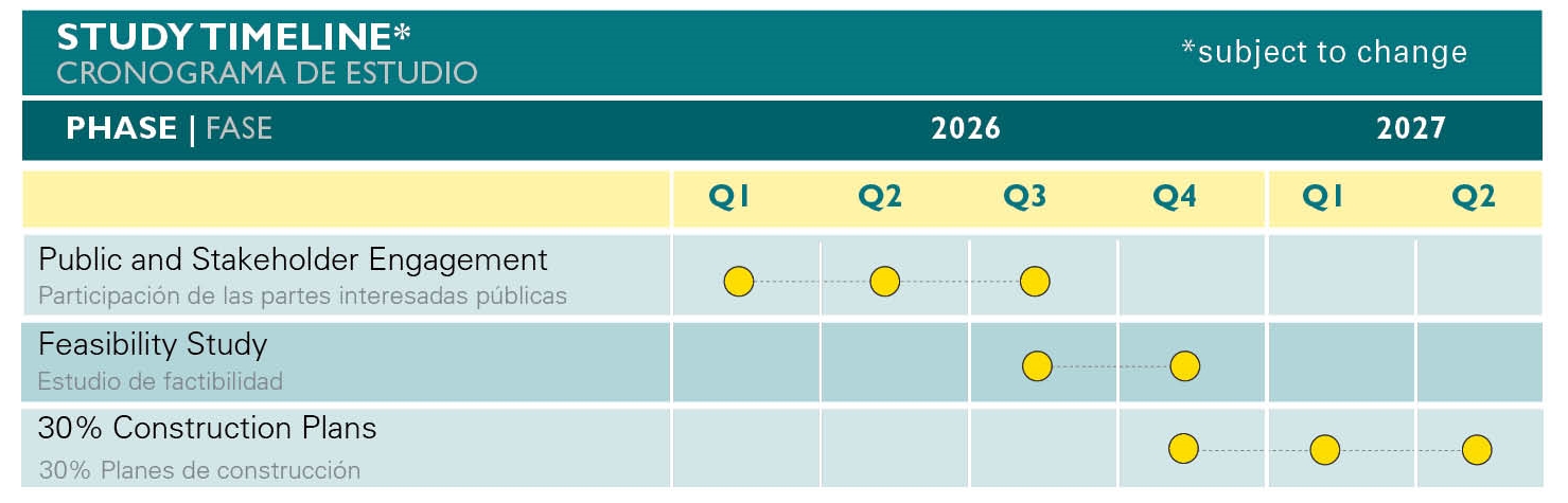
Project Schedule
Project Corridor Description
- Approximately a 7-mile corridor, from Havenwoods State Forest in the north to the Menomonee Valley in the south (connecting to the Hank Aaron State Trail)
- The rail corridor includes at-grade, above-grade and below-grade conditions
- 9 railroad bridges over City of Milwaukee streets or rivers
- 11 City of Milwaukee bridges over the railroad
- One railroad underpass at I-94
- 3 at-grade railroad crossings at City of Milwaukee streets
- Rail right-of-way is typically 100-ft wide, mostly single-tracked
- Adjacent land uses include a mix of industrial, commercial, and residential, with limited institutional
- Encompasses over 20 neighborhoods in the City of Milwaukee
Existing Corridor Conditions

30th St. Corridor view from Galena St.

30th St Corridor near 35th St

A view of the 30th St. Corridor over the Menomonee Valley

30th Street Corridor view near Century City

Near Custer Playfield
30th Street Corridor Trail Feasibility Study Frequently asked Questions
What is the anticipated timing for this project?
The feasibility study will be completed in mid 2027. Future phases of design and construction of the trail will be dependent on the ability to obtain funding. Any portions of the trail constructed through the rail corridor will need to be approved by the landowner, the railroad.
Why is a trail needed in this area?
Residents on the west and northwest sides of Milwaukee have limited access to existing trails. The 30th Street Trail has the potential to connect several regional trail systems to create an 18-mile Milwaukee Loop, including portions of the Hank Aaron State Trail, the Oak Leaf Trail, and the Beerline Trail.
Is a trail next to an active rail line safe?
Yes, there are many examples of rail-with-trail projects around the country that are designed with proper setbacks and fencing to separate trail users from rail activities. One local example is the Kinnickinnic River Trail on the south side of Milwaukee, which parallels an active rail line between E. Washington Street and E. Maple Street.
Is the study evaluating alternatives to a trail within the rail corridor?
This feasibility study is evaluating on-street alternatives for a trail network if it is determined that a trail next to the rail isn’t feasible
Who owns and operates the railroad corridor?
The railroad right-of-way within the project study area is mostly owned and operated by Wisconsin & Southern Railroad (WSOR, parent company WATCO). The portion of the rail north of W. Hampton Avenue is owned by the Wisconsin Department of Transportation and operated by WSOR. Canada Pacific Kansas City (CPKC) operates the southernmost portion of the rail south of W. Wisconsin Avenue.
How will the community be involved in shaping the study?
The feasibility study scope includes three rounds of community and stakeholder engagement. The first round is being held in February 2026, the second is anticipated in April 2026, and the third will be held in summer 2026. For each round, there will be a public information meeting, stakeholder meetings, Public Advisory and Technical Advisory Committee meetings, website updates and public surveys. Feedback from the meetings and surveys will be used to develop alternatives, evaluate alternatives, and to create a preferred plan that best reflects the community’s priorities and the physical constraints of the corridor.
Is this study related to the development planning happening in the corridor?
A coalition led by the Near West Side Partners along with the 30th Street Industrial Corridor Corp (The Corridor), Rails-to-Trails Conservancy, Northwest Side Community Development Corporation, and Havenwoods Neighborhood Partnership, has received a $1.6 million Reconnecting Communities grant from the USDOT/Federal Highway Administration to complete a Development Plan for the 30th Street Corridor.
The Development Plan will be a community-driven plan aimed at improving quality of life by identifying opportunities for economic growth, workforce development, advancing affordable housing, and providing transportation alternatives along the corridor and in surrounding neighborhoods. The planning process is anticipated to kickoff in early 2026 and take three years to complete. The process is intended to lay the groundwork for thoughtful and planned development in the corridor to support local residents and businesses as investments are made in the corridor surrounding the future trail project.
The coalition leading the Development Plan is collaborating with the Engineering Feasibility Study team to ensure the two plans are well aligned, and to limit redundancy with the community engagement process. The Engineering Feasibility Study is focused on the technical development of the trail while the Development Plan will be centered around advancing
Will this study preclude future rail operations in the corridor?
No. The intent of this study is to determine the feasibility of a trail while ensuring existing and future rail operations will be maintained.